By Karlee Deatherage, Policy Analyst
On a rainy day in the middle of November, over 60 people with diverse backgrounds — from farming to waste management — packed the Ferndale Library for the Whatcom Food Network’s 2017 Fall Forum. The main attraction was a presentation and panel on the state of farmland in Whatcom County. RE Sources has been a member of the Whatcom Food Network since the early days of its formation and we currently serve on the Steering Committee.
We believe healthy communities depend on a thriving local food system. But what does a thriving local food system even look like?
 “Once farmland is paved over, it can never be farmed again.”
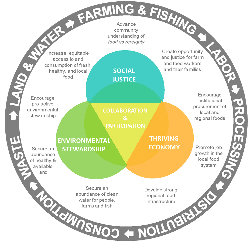
This image developed by the Whatcom Food Network lays it out nicely. The outer circle explains the people and processes necessary for a food system and how they are interdependent. The middle circle explains the vision of a local food system. The inner circle is the oft-referenced “triple bottom line” of sustainability with collaboration and participation at the core of everything.
In order to have a local food system, farmland must be preserved. Farmland acreage in the Puget Sound region has been declining since the 1950s. Over 60% of the farmland base in our region has been lost to building housing, manufacturing or other uses. Keynote speaker Hannah Clark of the Washington State Association of Land Trusts put it this way: “Once farmland is paved over, it can never be farmed again.” Not only does paving over good soils ruin them permanently: it also prevents soil from naturally filtering water runoff, adding pollution to our waterways.
Protecting farmland from development
The methods for determining farmland loss are not well documented, but development pressures appear to be key. The Puget Sound region has one of the highest population growth rates in the country. You’ve probably seen the headlines about 1,000 people moving into the Puget Sound region every week.
How do we accommodate this growth while protecting our farmland base? In Whatcom County, we have a goal of maintaining 100,000 acres to be available for agricultural use. We currently have 87,412 acres protected from intense development, but about 115,000 acres are farmed, according to the 2012 agriculture census. This means the other 27,000 acres could be at risk. Whatcom County has a number of tools to maintain our current farmland acreage and meet the 100,000 acre protection goal. Such tools include the Purchase of Development Rights (PDR) program and zoning. Nonprofits like the Whatcom Land Trust can also help protect farmland by working with willing landowners to obtain conservation easements.
One innovative method to both protect farmland while encouraging density in urban areas is under discussion at the County’s Transfer of Development Rights work group. This concept is known as a density credit program. RE Sources, along with developers, planners from the cities, farmers, and realtors all have a seat at the workgroup. If implemented by Whatcom County and the cities, density credits could be purchased by developers looking to build in designated areas to receive certain benefits such as increased density, reduced parking requirements, allowing attached or detached dwelling units, and more. The funds generated from density credits would be allocated to the Purchase of Development Rights program to protect farmland.
Everyone can play a part in the Whatcom Food Network and our local food system — whether you’re a farmer, a consumer, a fisher, a restaurant owner, an advocate for clean water, a farmworker, a food processor, or all of the above — the system needs all elements in order to properly function.
For more information about the Whatcom Food Network, visit www.whatcomfoodnetwork.org. Community forums happen each spring and fall and are open to the public.

 “Once farmland is paved over, it can never be farmed again.”